
Google Research Introduces Planetary Prediction Engine for Earth AI
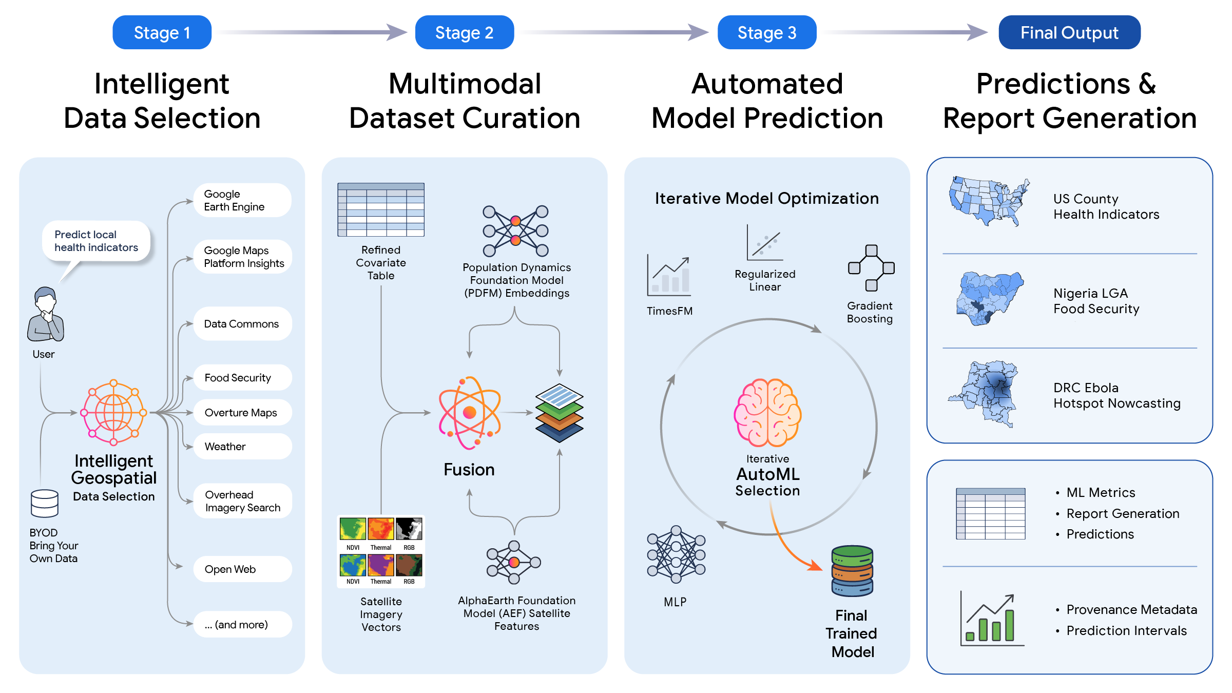
Google Research has introduced an experimental Planetary Prediction Engine that uses AI agents to discover geospatial data, train predictive models and generate results for real-world Earth and public-interest tasks.
Google Research introduces an autonomous Earth AI workflow
Google Research published its Planetary Prediction Engine (PPE) on August 27, 2026 as an experimental research capability for building global predictive models from geospatial data. The accompanying paper was submitted to arXiv on August 26, 2026.
PPE is research, not a generally available Google product or API. Google describes it as an early-stage system designed to automate parts of the geospatial machine-learning workflow that normally require specialists to discover datasets, prepare features, train models and evaluate results.
How the Planetary Prediction Engine works
Google describes PPE as an LLM-orchestrated workflow with three broad stages.
First, the system identifies relevant geospatial data and prediction targets. It can select public datasets and Earth foundation-model embeddings, then create training examples while attempting to avoid leakage and overfitting.
Second, PPE builds and trains prediction models. The workflow chooses representations and model configurations, executes training, and evaluates the resulting system.
Third, it generates predictions and a structured report explaining the task, data, methodology and results.
Google says the system can reduce some modeling workflows from weeks to minutes, although that claim reflects Google's research setup rather than a universal production benchmark.
Reported benchmark results
Google reports that PPE was evaluated across public-health, disaster-risk, vulnerability and food-security tasks.
On a set of 21 US Centers for Disease Control and Prevention health indicators, Google reports a mean R² of 76.8%, compared with 60.0% for its benchmark reference. On FEMA risk prediction, it reports 64.9% versus 60.0%, and on the Social Vulnerability Index 66.2% versus 58.6%.
For a Nigeria food-security task, the paper reports an R² of 66.1% versus 31.5% for the comparison baseline.
Google also describes a retrospective DRC Ebola-spread experiment using the 2026 Bundibugyo outbreak. PPE reportedly reached 83.3% Recall@10 and identified 15 of 18 newly invaded health zones, about 10.3 percentage points above the cited baseline.
These are author-reported research results, not independent operational validation.
Why this matters
Geospatial machine learning is often bottlenecked by data discovery and task-specific engineering rather than only by model architecture. A system that can autonomously assemble appropriate Earth data, build a model and produce a reproducible report could make geospatial AI more accessible to researchers and public-interest teams.
PPE is also notable because it combines general-purpose AI agents with specialized Earth foundation-model representations instead of treating geospatial prediction as a single monolithic model.
Potential use cases include public health, humanitarian response, disaster risk, food security, environmental monitoring and other spatial prediction tasks.
Release status and limitations
Google explicitly describes PPE as early-stage research. The company has not announced a broadly available hosted PPE service, developer API or production SLA.
Real-world use would require careful review of data quality, geographic bias, leakage controls, uncertainty, temporal drift and the consequences of incorrect predictions. High-stakes public-health or humanitarian decisions should not rely on benchmark scores alone.
The research is nevertheless a significant example of agentic AI moving beyond text workflows into automated scientific and geospatial modeling.
This article is built from the source material below. Open the originals for full context and the latest updates.
